

History and context
Torre Sarrió cannot be understood in isolation: it is part of the defensive network raised in Alicante's Huerta to protect civilians and farmland from the raids of the Barbary corso.
A prosperous huerta on a hostile sea
From the Late Middle Ages, the Huerta of Alicante —irrigated by the Tibi reservoir through a complex system of channels— was fertile land devoted to vine, cereals, fruit trees and Fondillón wine. That prosperity attracted the Barbary corsairs, who from Algiers, Tunis or Bugia ravaged the Mediterranean coast in swift raids —razias— in search of goods, livestock and captives for the slave market.
Throughout the 16th century, the Crown and the municipality articulated a comprehensive defensive system: watchtowers along the coastline, refuge towers inland next to the farmsteads and fortified defence towers linked to the inhabited nuclei. The consulted documentation records up to 43 towers in the Alicante huerta; 25 still stand today, largely absorbed into the urban fabric of Albufereta, La Condomina and Santa Faz.
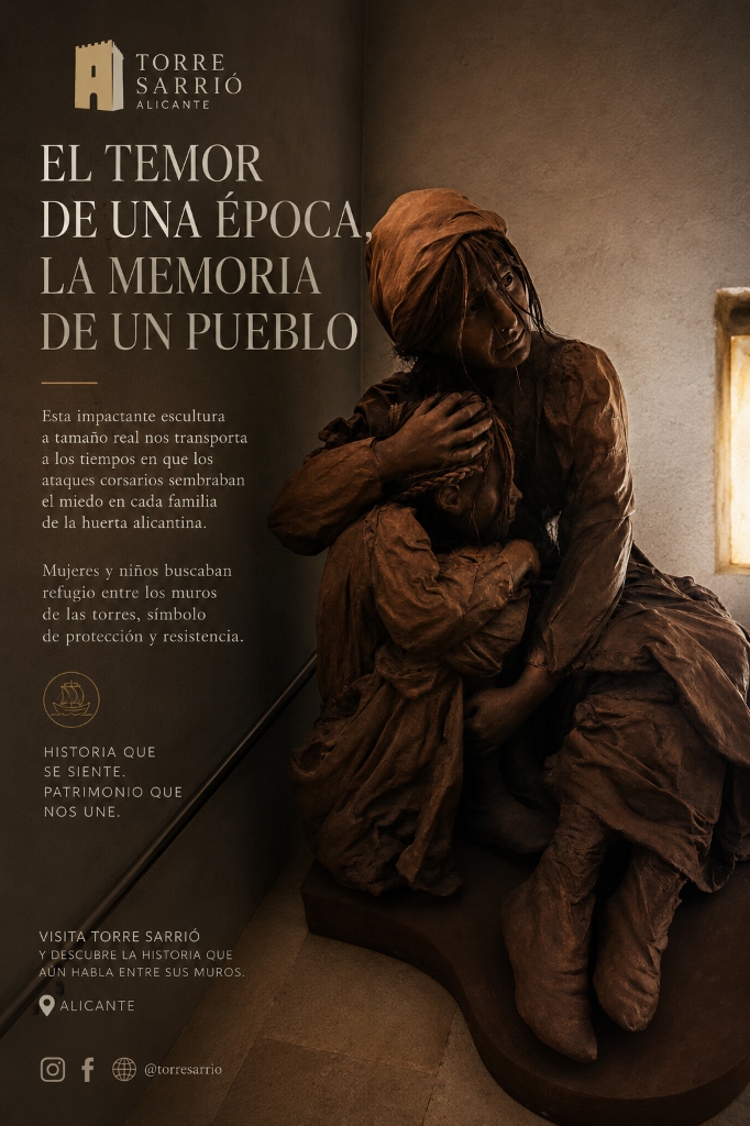
«This poignant life-size sculpture captures the human drama experienced by rural families of Alicante's Huerta facing Barbary corsair raids.»
The Fear of an Era, the Memory of a People
When the alarm bells sounded and smoke columns rose, survival depended on reaching the stone bastion in time.
In the fertile Huerta of Alicante, danger arrived without warning from the sea. At the first alert and rising smoke signals connecting the tower network, farmers, women, and children rushed from the fields toward the nearest defensive stone tower.
Behind the 1.5-meter-thick stone walls of Torre Sarrió, panic turned to endurance. In the dim light of the vaulted semibasement, families held their breath as corsairs torched orchards and farmsteads outside. Those walls were not merely stone; they were the thin line between life, enslavement, or death.
Wednesday
17
March · 1540
The Barbary raid during the Santa Faz pilgrimage
Coinciding with the annual pilgrimage to the Santa Faz Monastery, the corsairs fell upon the Alicante huerta in a particularly brutal attack. The date remained etched in the city's collective memory and hastened the consolidation of the network of refuge and watchtowers throughout the second half of the 16th century, of which Torre Sarrió (1594) is one of the latest and best documented examples.
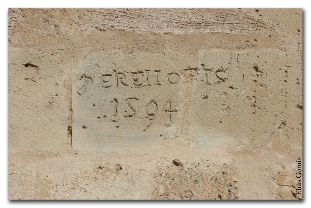
«PERE LLOPIS 1594»
Carved on the talus of the tower —covered until the restoration by almost a metre of fill— appears the inscription of the builder or promoter. Beside the signature, marks interpreted by historians as bullet impacts remain, possibly linked to episodes of the Peninsular War (1808–1814), in which the tower is said to have been the scene of executions.
From Fertile Garden to Fossilised Landscape: Eight Centuries of Alicante's Huerta
The Huerta of Alicante represents one of the most unique water landscapes in the Iberian Peninsula: a coastal alluvial plain of some 3,800 hectares whose history is defined by a fundamental paradox: the relentless struggle against endemic water scarcity and the violent flash floods of the Montnegre River.
The Foundations of the Huerta
A design born of scarcity: Andalusi origins, Alfonso X's division and water-land unity
The Tibi Dam Revolution
A Renaissance engineering masterpiece, the Major Channel and the golden age of Fondillón
External Inflows and Smallholdings
Water channels from afar and the harmonious symbiosis of towers, wineries and family plots
The Dramatic Rupture & Urban Pressure
Mass tourism, zoning by exclusion and an 81% collapse in active agricultural holdings
The Stark Landscape Contrast
From historic garden to fragmented suburban terrain in La Condomina, Fabraquer and Mutxamel
A Fossilized Legacy Still Resisting
150 protected heritage assets, 45% of regional heritage and the goal of unified landscape management
Historical Monograph & University Research
This synthesis on the evolution of Alicante's Huerta, its water landscape and territorial transformation is grounded in authoritative academic scholarship. We express our deepest gratitude to Prof. Dr. Jorge Payá Sellés (University of Alicante) for his exceptional generosity in sharing and contributing his monographic research on historical water rights and irrigation to enrich this cultural project:
Esmeralda Martínez Salvador
University of Alicante / GeoGraphos
Study on the water landscape, territorial contrast and the transformation of the traditional huerta amid contemporary urban sprawl.
Dr. Jorge Payá Sellés
University of Alicante / Dept. of Legal History
Doctoral thesis and monographs on the water rights regime of the Verde-Monnegre basin (13th-18th centuries), royal charters and irrigation ordinances of the Huerta.
Verónica Quiles López
Historian and Heritage Documentalist (Proyecto TERRA)
Research on the 18th-century splendor of Alicante's Huerta, ethnographic study of wine presses (cups), animal-driven oil mills and material culture.
Antonio Campos Pardillos
Huerta Towers & Regional Heritage Researcher
Authoritative thesis on the evolution and gradual decline of the traditional huerta: from the Fondillón wine boom and phylloxera to irrigation crises and urban land reclassification.
From fortification to Interpretation Centre
Five centuries of use in three stages: defence (blue), the tower as farming heritage (ochre) and the contemporary period (stone).
- 1248
Conquest of Alicante (Middle Ages)
Infante Alfonso of Castile (later Alfonso X the Wise) takes the Muslim citadel on Mount Benacantil on December 4th (feast of Santa Bárbara), giving rise to the Christian fortress and coastal defense.
- 1258
Charter Water Division of Alfonso X
Alfonso X regulates the irrigation of the Montnegre River into 672 charter water streams and consecrates the principle of inseparability between water and land, structuring the medieval farmsteads.
- 15th c.
Rise of the North African corso
The Alicante coast suffers increasingly frequent raids by Barbary fleets.
- 17 Mar 1540
Raid on Santa Faz
During the annual pilgrimage, corsairs strike the Huerta hard. The episode speeds up the consolidation of the tower system.
- 1553–1594
Unitary Project: Tower, Vestibule and Cistern
According to archaeological excavations by ARPA Patrimonio / MARQ, the tower, the wide segmental arch of the vestibule and the subterranean cistern were built synchronously as a single 16th-century project (explaining why only the South and West facades feature a 2.40 m talus). In 1594 Pere Llopis carved the inscription on the West talus: «PERE LLOPIS 1594».
- 17th–18th c.
Ennoblement and Fondillón Winery
Winery conversion of the complex: the lagar-cellar was fitted with a press, settling tanks and stone cart tracks for Fondillón wine production, consolidating the manor house.
- 1808–1814
Peninsular War
Impacts on the wall attributed to executions during the conflict.
- 20th c.
Agricultural crisis and abandonment
Phylloxera, water scarcity and rural depopulation degrade the huerta's farms.
- 1995
Final abandonment
Successive fires affect the tower.
- 1998
Roundabout
The building of Vía Parque surrounds the tower and conditions its access.
- 2010
First restoration
Intervention led by architect Màrius Bevià (€420,838). The talus is recovered and cracks consolidated.
- 2021
Second phase of rehabilitation
The architectural enhancement of the tower + house is completed.
- 8 Jul 2026
Opening as Interpretation Centre
Inauguration with content from MARQ and the MARQ Foundation; museography by Rocamora Diseño y Arquitectura.